

WATKINS GLEN, Apr. 4, 2024 — Three state inspectors dropped by the Padua Ridge gravel mine on cold, cloudy December day in 2010 to order the owner, Martin Wojcik, to halt operations because his permit had expired 13 months earlier.
They also noted that he’d been mining outside the 14.33-acre site covered by the expired permit. Wojcik’s excavators had been illegally chewing into the hillside separating the mine from St. Mary’s Cemetery and the Watkins Glen State Park.
The state Department of Environmental Conservation later fined Wojcik $15,000 as part of a 2011 consent agreement that required him to regrade and plant vegetation to restore 3.72 acres mined outside the permitted site.
But that required reclamation wasn’t finished by August 2012 when the DEC awarded Wojcik’s company, It’s Greener Now Inc. (IGN), a new five-year permit to mine again.
In fact, five years later, when that newer permit was close to expiring, an inspector wrote that it could not be renewed until the 3.72 acres were properly graded and vegetated. Wojcik was also told to take steps to control dust and stop stormwater from flowing off the site.

Eventually, a DEC inspector deemed IGN’s operation “acceptable,” and the agency issued a new permit though 2022 and closed the consent agreement.
Meanwhile, Wojcik was busy illegally removing material from land on the north side of State Route 409, where he has never had a permit to mine, the agency said in a notice of violation dated Dec. 3, 2021.
That led to a $25,000 fine, a new consent agreement and the required reclamation of 8.5 illegally mined acres.
Once again, the DEC struggled to win compliance.
Eighteen months after Wojcik had signed the legally binding 2022 consent agreement, a DEC inspector wrote to an IGN consultant: “Today I inspected the Padua site (across the street from IGN permitted mine) that removed material without a permit. The site is nowhere near an approvable reclamation.”
DEC has now granted Wojcik two extensions to that consent agreement’s deadline for cleanup, pushing it into this year. The latest deadline: June 15.
While that illegally minded area north of Route 409 sat unreclaimed, the DEC announced in January that it had approved for public hearing Wojcik’s application to quintuple the size of his IGN mine south of 409.
News that IGN was seeking to expand from 14.33 acres to more than 75 acres came as a shock to officials in the Village of Watkins Glen and Schuyler County, who immediately objected.
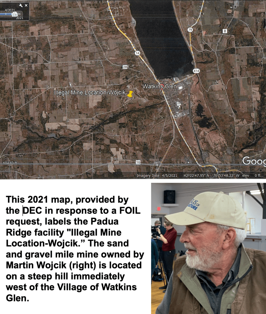
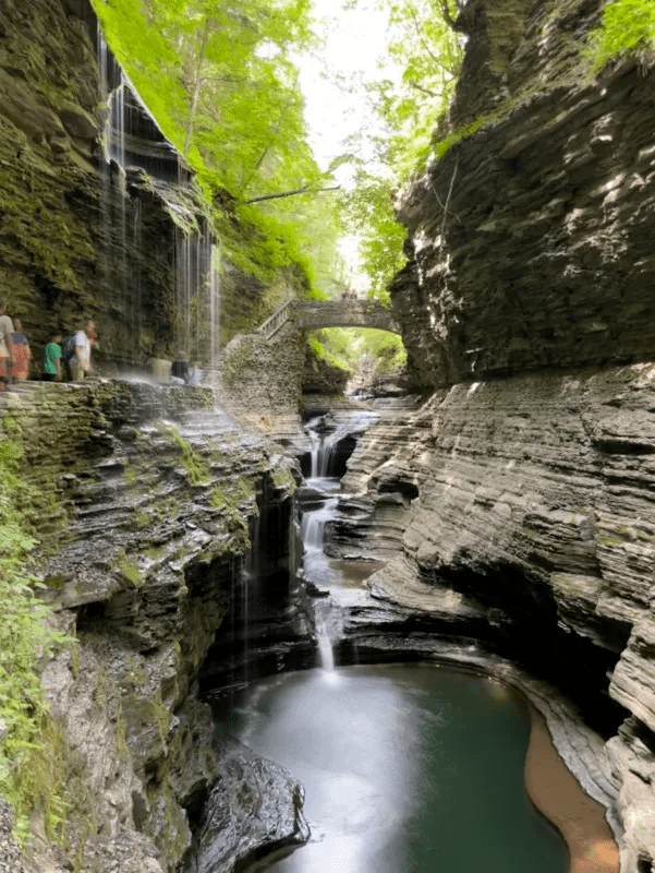
The mine is located on a steep hill above the village. It borders the area’s vital tourist magnet, the Watkins Glen State Park, and the cemetery.
Local officials and residents had long assumed Wojcik’s dreams of expanding the mine died in 2008 amid fierce local opposition. They were never told that the DEC had been negotiating with Wojcik over the past six years on a plan for a major expansion.
But once the agency formally accepted Wojcik’s 784-page draft environmental impact statement (DEIS), it was required by state law to disclose it and hold public hearings.
So it sent a terse Jan. 10 letter to Watkins Glen Mayor Laurie DeNardo and ordered the delivery of two giant binders containing a paper copy of the DEIS.
At first, agency officials insisted on providing the public only a brief time window to digest and comment on the voluminous document: until Feb. 28. At a public hearing at the community center Feb. 13, at least 20 speakers voiced objections. Part of the time, Wojcik sat silently and watched.
Yielding to public pressure from DeNardo and others, DEC extended the comment period to April 13.

DeNardo said today that she had not been aware of the enforcement actions the agency has taken against Wojcik. “The fact that the DEC already has consent orders and violations that he hasn’t complied with should be enough to shut this new permit application down,” she said.
Wojcik did not return a phone call seeking comment.
Even as agency officials were quietly negotiating details of Wojcik’s expansion plans in May 2023, the DEC fined him a third time — for $25,000 — and executed a third consent agreement involving the illegal excavation of 1.6 acres outside the mine’s permitted border.
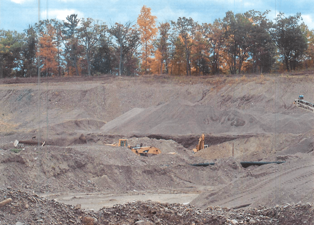
This report is based on hundreds of letters, emails and other documents, maps and pictures that DEC provided in response to WaterFront’s requests under the Freedom of Information Law. And a review of mine inspection reports dating back to 2007 revealed dozens of alleged violations of state rules aimed at, among other things, controlling erosion, preventing stormwater from escaping the site, minimizing dust and avoiding excavation into the water table.
According to the reports, the agency often had trouble obtaining Wojcik’s prompt compliance after confronting him with alleged violations.
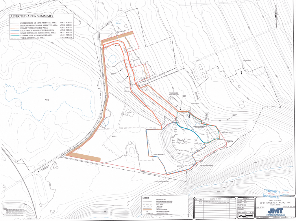
In fact, most or all of the 3.72 acres mined illegally from the ridge next to the cemetery and state park is now part of Wojcik’s plan to expand his permit from 14.33 acres to 75.28 acres.
And if the DEC approves his DEIS unamended, Wojcik would face little or no pressure to continue to grade and seed the area that the 2011 consent decree had required him to reclaim. The 784-page document the agency approved for public comment places a low priority on reclamation because it only requires that “the area of disturbance never exceeds 50 acres.”
While the gravel pit’s longstanding boundaries around 14.33 acres allowed for an untouched buffer zone of 200 feet or more between the mine and the state park and the cemetery, the planned expansion would drastically shrink it.
The prospect of virtually eliminating the buffer alarmed the state Office of Parks, Recreation and Historic Preservation (the Parks Office, or OPRHP).
“It is our belief that an expansion of the mining operation up to the boundary of the state land has significant potential to adversely impact the historic character of the park,” the Parks Office wrote in July 2, 2019 comments on an early version of Wojcik’s DEIS.
It went on to say:
“We found no assessment of anticipated increases in noise, dust, vibration, truck traffic or other direct and indirect impacts that the expansion of this extractive industrial (facility) would have on the historic park.”
But those expressed concerns were all satisfied by “additional materials you provided,” according to a brief Dec. 10, 2021 letter to a Wojcik consultant that said: “It is the opinion of OPRHP that the project will have no adverse impact on historic resources.”
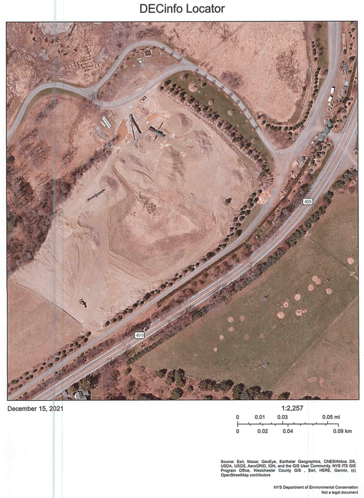
According to a map provided in the DEIS, the expanded mine would share a boundary of more than 1,500 feet with state park property. The map shows a buffer between the two of roughly 50 feet. The mine’s boundary along Route 409 would extend to within about 600 feet of the north entrance to the state park.
The same map shows a buffer between the mine and the cemetery property of less than 10 feet.
The expansion proposed in the DEIS does not include property that Wojcik owns on the north side of State Route 409.
That’s where Wojcik illegally mined “in excess of 750 cubic yards of minerals” (from 8.5 acres of land), according to the 2022 consent agreement.
That excavation activity north of Route 409 may have had an impact on neighbors’ property south of the road. A large culvert under 409 carries stormwater downhill from the north side of the road to properties to the south.
William Pylypciw owns 25 acres south of a long curve on Route 409. On that property, a drainage ditch runs from the culvert under Route 409 past the front of his house.
“When I bought my property 10 years ago,” Pylypciw said in comments to DeNardo later shared with the DEC, “there was a moderate sized drainage ditch that went by the front of my house. It handled any rain storms or snow melts we had.
“About six years ago, coinciding with Marty (Wojcik) digging across the road, there was a huge influx of water. Water filled with a lot of sediment.”
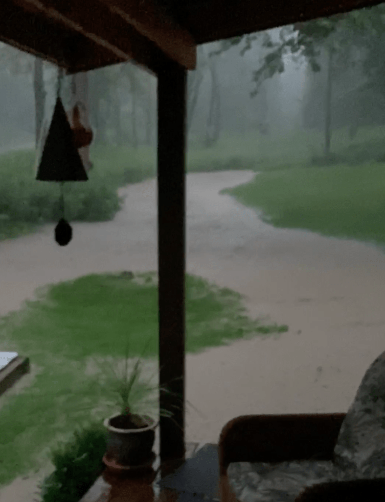
During one particularly heavy rain in July 2021 — which caused flooding in the village — Pylypciw took a video of the torrent flowing from the culvert under Route 409 past his home. He said the water and mud eventually surrounded his house entirely.
“This situation no longer exists thanks to recent DEC enforcement, but it took six-seven years for that to happen,” Pylypciw said, giving credit to the agency for directing Wojcik to reroute stormwaters to reduce flows through the Route 409 culvert. “A village full of residents should not have to fear this happening to their homes.”
During recent heavy rains Wednesday, the ditch in front of Pylypciw’s house easily contained the flow.
Wojcik’s property north of Route 409 also drains into Quarter Mile Creek, which flows into Seneca Lake. Sediment flows from that tributary potentially threaten village drinking water because it empties into the lake near the village water system’s intake pipe.

LikeLike
Peter, please keep up your good work on this and the other environmental concerns that have to be monitored because “our” DEC seems to be so corrupt.
Much respect for your work. Peace, DaleLewis
LikeLike